This post contains notes from multiple days between Macduff and Rosehearty. There is one video episode that covers this whole section (at the end of this post).

I’m starting to do larger sections of trail, and my notes seem very scattered, especially since I waited weeks to post this…I’ll try to do better in the future. But for now, I’ll share a little recap of the area from Macduff to Rosehearty.
Macduff to Gardenstown
Method of travel: Hiking

During this section I encountered my first inaccessible coastline – my way was blocked by clifftop farms surrounded by barbed wire fences. I have read accounts of other hikers climbing over them and walking through farms to stay close to the cliff edges, but during my time there (August), the farmers were harvesting many of the fields with huge machinery plus I had no idea how to climb over the barbed wire without getting shredded. So I had to go inland to some of the small roads. This proved a huge challenge and really tested my fitness, as many of the roads are very windy/hilly – often with more than 20% grades. In addition, I was scared because many of the roads are 60mph with cars wizzing by. I often found myself jumping into dense grass and ferns to get off the road when I heard a car coming.

But if you can stomach it, it’s worth it (or just drive, like a sane person). Gardenstown is the first ‘big’ town after Macduff, tucked between massive cliffs rising from the sea. I spent some time wandering up the trails near St. John’s Kirkyard, a medieval churchyard (now in ruins), perched on a grassy clifftop. This site predates the town below by a few centuries and


The kirkyard (Scottish for churchyard) overlooks Gardenstown, the oldest structures sitting directly above the water near the harbour.

Gardenstown to Pennan
Around the ‘bend’ you’ll find Crovie, and soon after, Cullykhan Beach, a beautiful almost tropical-looking beach.


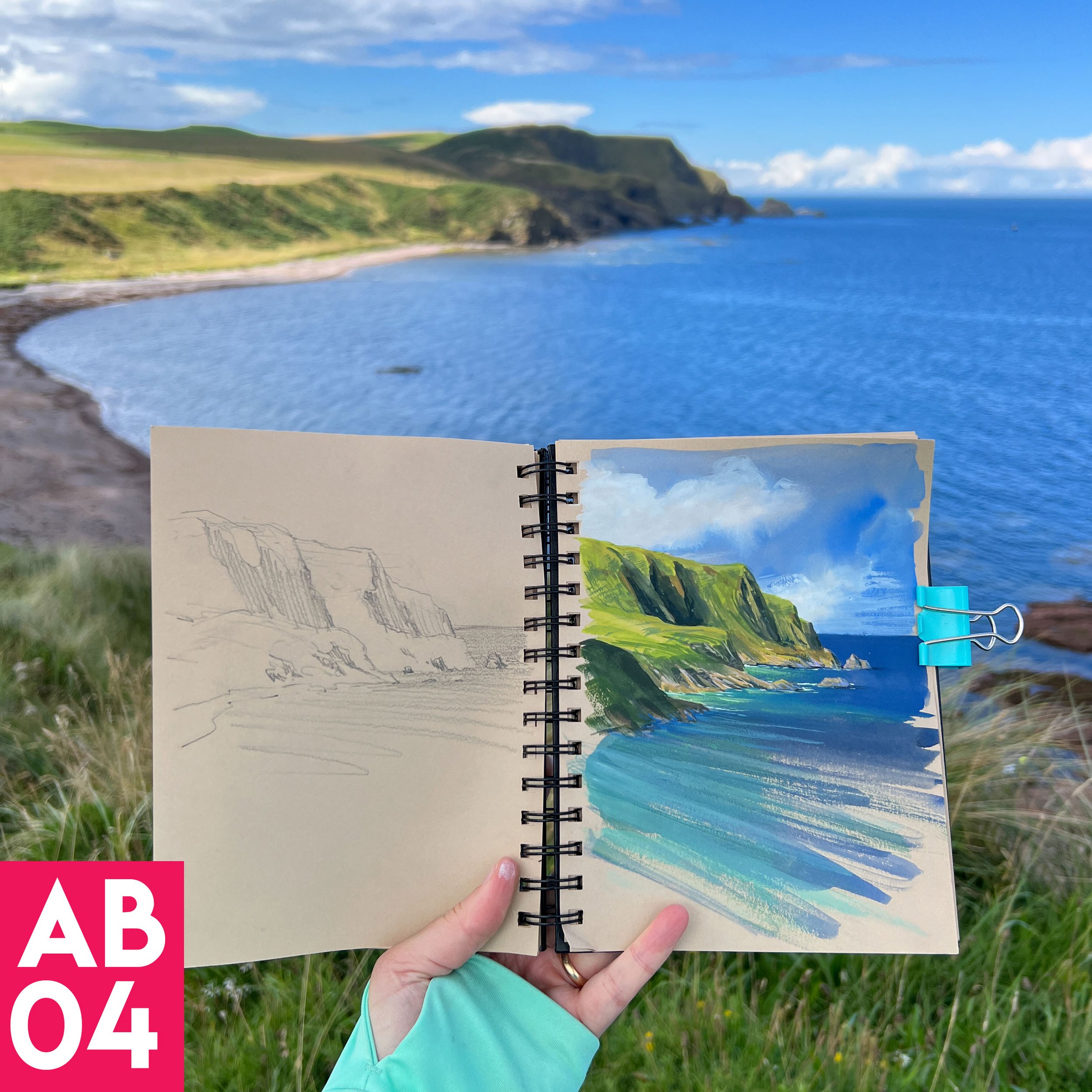
There’s so much to explore here – I’ve painted the cliffs a few times, but mostly it’s just a beautiful place to walk and looks for dolphins, whales, seals, sea birds and field critters.
Pennan is another great place to stop, famous as one of the filming locations of the legendary ‘Local Hero.’


Pennan seems like one of those quintessential coastal towns. The local residents have placed picnic tables and benches along the entire shore and lots of cute decorations. In addition there are free public toilets. However the town is not built for large crowds, and I could see how it might be overwhelmed if there were too many visitors.
Sadly I witnessed a group of visitors on the shore being a little rambunctious, and as soon as one of them began flying their drone, a local woman yelled at him to get away from their homes. It was an obvious example of what not to do when visiting a town. Don’t act like you own the place. Don’t fly near private homes and lots of people. I felt bad for that resident who needed to yell at them. I had a feeling it happens more than they like.
Anyways, one of my favorite things was the little harbour coffee hut known as the Coastal Cuppie. Highly recommend!


If you have the chance, a day trip driving between Macduff and Pennan would be great way to get a sense of this area.
But now it’s time for the jewel of the area:
Troup Head RSPB
(RSPB: Royal Society of Preservation of Birds)

This was one of the coolest experiences I’ve had along the entire coast so far.
Troup Head is one of over 200 RSPB locations in the UK, and is Scotland’s largest colony of Northern Gannets. Gannet’s are the largest seabirds of the North Atlantic, with wingspans of up to 6 1/2 feet!
Seeing these giant birds in person was spectacular, especially because there were some chicks in the nests. It’s also home to many other birds including kittiwakes, guillemots and razorbills. Puffins are there during spring and summer but leave in August.

There were so many birds that the sound was overwhelming at times. I carefully walked along the cliff tops – which are mostly ‘at your own risk’ depending which path you take. But the coastal path is well worth it, as it allows you to view the nests below. Thankfully you don’t have to lean over the edge to see many of the nests, and with a long zoom lens it feels like you’re right there with them!


Picture the 6 foot wingspan!


The gannets begin migrating south between August and October, so I was really happy they were still there during my visit.
I wanted to stay for hours, but I could see rain clouds headed my way, so I left the trail to start the loop back to my car.
I would pick up where I left off a couple of weeks later.
Let’s move onto the next portion of this adventure – the start of my 3-day 90 mile bike ride!
Leg 01: New Aberdour Beach to Rosehearty (3 miles)
Method of transportation: bike
This was my first time to New Aberdour Beach. In order to give myself enough time to get to know this area, I had Wolfy drop me off at the beach with my bike and all of my gear. I planned on spending the entire day exploring and painting before heading to my first night’s accommodation down the road.
Not only are there sea caves and sea arches, but a short hike up the trail leads to amazing views across the bay of turquoise waters.


When the tide is high, the sea caves are inaccessible. There are lots of tide pools to explore and I saw lots of little fish swimming around the seaweed.

I love the colors of these sandstone and limestone cliffs. There are lots of smaller rocks and shells embedded into the rock which glitter in the sun.


At the carpark, there’s a freestanding toilet block which was pretty clean. There were only two other families when I was there, and it felt like I had the whole beach to myself.
I have to admit, I was a bit nervous to start my journey. This was the longest bike ride I have ever done – 90 miles over three days. Everything I needed to survive was packed onto my bike, and I had booked accommodation both nights. Someday I’d like to try bikepacking (wild camping along the way) but I’m not quite ready and don’t have enough panniers. But I made it really easy to start this trip by booking a camping pod close by, saving the big miles for days two and three.
Soon the bright patches of light were replaced by deep bluish green shadows. I saw big rain clouds moving in, so I decided to hit the road and see if I could outride the storm.
Once again the cliff tops were blocked by farmland lined with barbed wire fences, so I had to head down the nearest farm road. Thankfully it was close enough to get good views over the water.

A Close Call
Unfortunately I got caught in a scary thunderstorm. In retrospect I wish I had waiting a little longer and hid in the sea cave!
The rain came on so suddenly, as it often does here – from a light sprinkle to buckets of rain in a matter of minutes. It was so heavy I couldn’t see more than a few feet in front of my bike. I found a spot to pull over, dropped my biked, and huddled under my umbrella on the side of the road until the torrential sheets of rain stopped slapping me in the face. My priority was getting low to the ground in case of nearby lightning strikes. There was one moment when the flash of lightning and thunder were nearly simultaneous – I was in the heart of it. I was terrified!
I felt so exposed.

There was a momentary break in the rain, so I threw my camera into my bag and rode a mile or so east until I found a barn to hide in. Luckily the workers there didn’t mind at all. The rain and thunder continued for about 20 minutes.
Finally, the rain subsided just long enough for me to pedal the rest of the miles to my camping pod. Parts of the road were flooded so it was slow going.
Lesson learned: If it looks like it’s about to sprinkle, assume it will be a storm. Put all electronics in the bag, cover in a poncho, and ride as fast as possible to a nearby barn.
Note to self: buy a poncho.

I was staying in this little pod at “Down on the Farm,” which was the perfect place to have a hot shower and enjoy a cuppa while looking out over the water. After the storm, a beautiful sunset moved through. I enjoyed my rehydrated meal and popcorn while watching the sheep grazing outside my window.


Beautiful way to end a dramatic day.

Watch the video episode: