The Journey Began: July 27, 2022.

Day 01: East end of Moray county to Portknockie Village (4 miles)
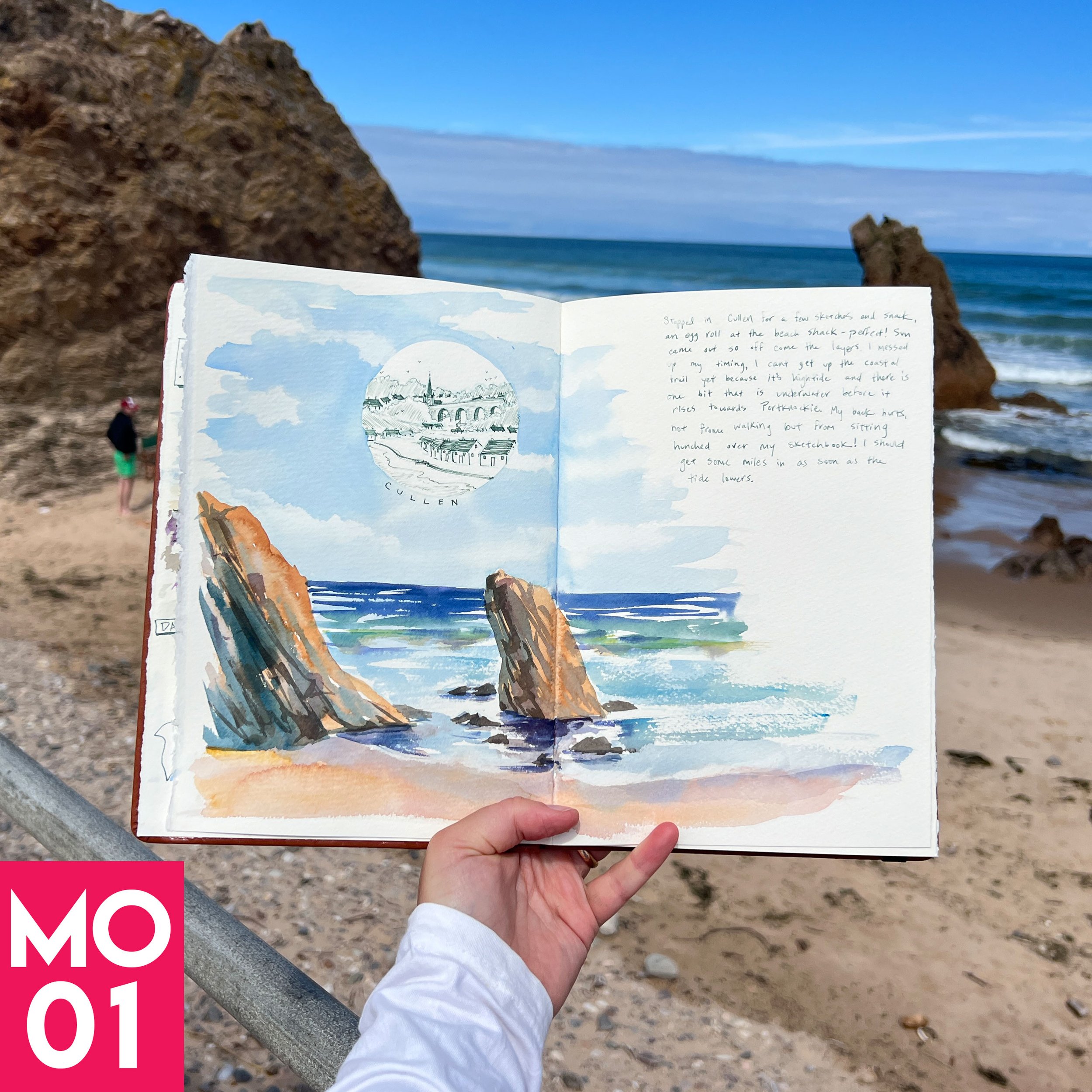
The journey began with a “quick” bus ride to Cullen, if quick were allowed to be in the same sentence as bus.
From Cullen town center I hiked northeast to the Moray Coast Trail start point, then a little farther until I was standing on the edge of Moray County.

I sat at the Salmon Bothy ruins and tried to remember by mantra. One painting at a time. One step at a time. I started my first sketch of the journey with trepidation. What if it’s not perfect? What if I ruin the first page? Every artist knows this feeling.

And guess what? It wasn’t perfect. And that’s OK. I was there, living my dream.
Clouds threatened to rain, so I hit the trail walking west towards Cullen Beach. A quick drone flight revealed blue skies headed my way, so I relaxed a bit with an egg roll from the food truck at Cullen Beach – fast and filling.
After sketching the iconic sea stacks on the beach and a mini portrait of the town behind me, I felt ready to get some miles in…or at least find the next spot to paint.

As I walked along the beach I quickly realised my first mistake of the day – I brought a plastic desktop tripod because I thought the lightness would be ideal. Boy was I wrong. Within the first hour, one of the knobs broke, which meant my camera or phone couldn’t be supported unless it was just perfectly vertically balanced. Even my phone (iPhone 13 pro max) was too heavy and the whole dang tripod kept falling over, sending my phone crashing into the sand. The short legs meant I had to constantly bend down to see if I was filming the correct way. Lesson learned: get a lightweight, strong, normal sized tripod.

At the east end of Cullen Beach, the trail follows the contours of the cliffs, and at high tide one tiny piece of the trail is under water. Luckily, I took so long to sketch at the sea stacks that the trail was dry by the time I arrived. After admiring a massive cave I tightened my straps and started heading up. Up, up, and more up.
Near the top of the cliff there is a small bench that looks down at the beach, but the show-stopper is the Whales Mouth, a diagonal sea arch just below. If only I had known the bench was there. Alas, I stopped too early and sat in the ferns half way up, straining my eyes to see the arch. My feet were happy for the rest though.


Finally, I clambered my way to the top of the cliff (I make it sound dramatic…there are literally concrete steps near the top) then looked back to admire the view. The vibrant colors took my breath away.


The coastal path follows the contours of the cliff top until you reach the other show stopper: Bow Fiddle Rock. There are thousands of photos of this sea arch for you to peruse online, but here’s my sketch instead:

After a mini picnic, I realised I was out of water and food (another big lesson learned) and so completely drained that I decided it would be best to end the day and catch the bus home.
I barely had enough phone battery (another lesson learned) to check the schedule online and navigate to the bus stop, but not without a quick visit to the harbour to use the free facilities. By the way, I recommend using every single free public toilet you can while hiking the Moray Coast Trail, because you never know when the next one might be closed.

It was an amazing start to the journey. But it wasn’t over yet!
We had a wedding to attend, so I traded my leggings for a dress and overindulged for a night…as one does.
Day 02 – Portknockie to Portgordon (7.5 miles)

Two days later, I picked up where I left off at Portknockie Harbour, ready to work off those extra calories.
There are a couple of options for walking from Portknockie to the next town, Findochty (pronounced Finechty – get some phlegm in there with the cht). You can start in the town and walk along the golf course above the cliff, or you can start at the harbour and walk along the base of the cliffs. Did I say walk? I meant scramble, slide, and hop. Be careful of slippery seaweed and unstable rocks! I did both because I’m a masochist. Yep, I walked along the upper trail, and found a place to scramble down the rocks, then went all the way back and walked the lower trail.


But the lower path is far worth the effort. Spectacular cliffs, jutting sea stacks, and fascinating rock pools everywhere.
I took my time navigating the slippery stones until finding a nice perch to sketch. Another hiker walked by and told me there were seals near Buckie. SEALS! That did it. After that point I had a one-track mind for the rest of the day. Seals. Seals. Seals.

But that seemed unfair to Findochty, so I wandered into town and was instantly won over by it’s charm. It seems all of the homeowners got together one day and decided to paint their houses in the cutest way possible.
I found a bench near at the harbour, and painted something resembling boats while the sun beat down on me and I inhaled the loveliest scent of rotting seaweed. But hey, that’s coastal life. What could be better??

Onwards I ascended towards the large stone monument atop the hill to the west, like a beacon calling my name. There was a beautiful view of Findochty harbour from up there.


The heat of the day was wearing on me, so I turned east and hiked along the top edge of the cliff, skirting the golf coarse. Scared of being hit by a rogue ball, I hustled along until finally I was safe in Strathlene, which is directly before reaching Buckie and seems solely comprised of a golf course. I suppose it is the equivalent of a hamlet of Buckie? Anyways, seals.
I was 4 miles into a 7 mile journey, so I blacked out between Strathlene and Portgordon. This stretch felt very flat, dull, and especially industrial in Buckie. If you don’t have seal-brain, I recommend walking up into Buckie and skipping the coastal harbour road. You can get some nice coffee and relax in town and admire some of the old buildings.
But the promise of seals dangling in my brain prodded me forward. The last bit of mileage between Buckie and Portgordon is flat and hugs the road. For ages the heat of the day played tricks on my eyes, and I kept thinking there were seals on the road up ahead.


Alas, no road seals. But right as I entered the eastern edge of Portgordon, hope was rekindled. I heard a strange moaning sound. I stepped lightly along the trail as it carves its way between some houses and the shore, making me awkwardly feel like I was walking in someone’s back garden.
A few more steps and low and behold, on the waters edge there were at least 50 lounging seals. Rolling, flopping, moaning, splashing, and eating. I kept my distance, using my iPhone to zoom in to see them properly.
They had some pups, but most of them were bigger than any human I know. When they opened their mouths, I could see large pointy teeth.
Black, grey, spotted, white. Whiskers. Blubber. SEALS!
My day was made. Seals.


My photos don’t do it justice. It’s just an iPhone after all. I was devastated that I didn’t have my big fancy Fujifilm camera and zoom lens. But, the experience alone was worth every aching step and I will definitely remember that forever.